According to the Oregonian, those are the forecast temperatures for today through Sunday. Eee-yuck! And to make matters worse, that's the Portland forecast. We often get it worse here in the valley... I should explain. 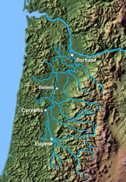
Northwestern Oregon and the Willamette Valley
The Willamette Valley, in plate-tectonics-speak is a forearc basin, not a true valley. Out to the west of my favorite coffee shop about 100 miles, the Juan de Fuca plate slides under the western edge of the North American Plate. Come in from there about 50 miles and you hit the coast. Between the coast and here is the forearc ridge, aka the Coast Range. The Coast Range extends up to southern Vancouver Island (Canada), and south to about Coos Bay (the little upside-down "V" in the southwest corner on the map above. South of Coos Bay there's still a topographic ridge associated with subduction, but the rocks are very different (the Klamath province is a freakin' mess that I don't want to touch right now), so it's considered a different range. Likewise with what is also known as the Coast Range in California- different rocks, different history, therefore different mountain range. The forearc ridge is a line of uplift associated with compression at a subduction zone. The subduction takes place on a north-south line, and the Coast Range parallels the subduction zone.
Likewise with the forearc basin... but let's jump ahead to the Cascades. When a subducting plate reaches a certain depth (I seem to remember 150 km- 90 mi- but I'm not certain), hydrated minerals start "sweating out" their water. This water moves into the overlying hot rocks, reducing their melting temperature slightly, and causes them to melt. The magma moves upward, and the portion that reaches the surface erupts as volcanoes. This set of volcanoes parallel to the subduction is called a volcanic arc: most are curved (arc-shaped), but the Cascades are short as arcs go, and its axis doesn't curve much. Hence, forearc ridge and basin: the ridge and basin on the forward side of the arc.
Likewise with the forearc basin... but let's jump ahead to the Cascades. When a subducting plate reaches a certain depth (I seem to remember 150 km- 90 mi- but I'm not certain), hydrated minerals start "sweating out" their water. This water moves into the overlying hot rocks, reducing their melting temperature slightly, and causes them to melt. The magma moves upward, and the portion that reaches the surface erupts as volcanoes. This set of volcanoes parallel to the subduction is called a volcanic arc: most are curved (arc-shaped), but the Cascades are short as arcs go, and its axis doesn't curve much. Hence, forearc ridge and basin: the ridge and basin on the forward side of the arc.

Marys Peak
While the Coast Range has passes at about 1000-1200 feet elevation, the Cascade passes are about 5000 to 5500 feet. Typical peaks in the Coast Range are 2000-3000 feet, with the high point 4101 feet at Marys Peak just west of My Favorite Coffee Shop... well, 14 miles as the crow flies. The Cascades peg out at the 10,000 foot range, with Mt. Hood topping out Oregon at 11,249 (Mt. Rainier in Washington is the overall Cascade champ at 14,410).

Mt. Hood
And in between these two mountain ranges lies the Willamette Valley. While the Coast Range has risen by compression, faulting and folding, and the Cascades by a build-up of lava, the Willamette Valley (aside from fluvial sedimentation), has not been raised up very much. It is referred to as a structural depression- its existence is not due to erosion by the Willamette River. And technically, a valley is created by erosion. While most basins in the west are referred to as valleys (sometimes as holes, like Jackson Hole), many are structural in nature, not erosional.
Now if you glance back at the relief map up top, you can see that the Columbia River cuts westward through the Cascades, swings north from Portland, then back to the west through the Coast Range. Throughout most of the length shown on this map, the Columbia is close to sea level. It's a great passage for air to move through in east-west directions. Here in Corvallis, we have high areas west and east. It's more difficult to get air movement across those mountains. Meaning that the air tends to heat up more (there's less mixing with air from the coast) and it doesn't blow out as well at night- so we have warmer nights. So we will probably get higher temperatures than those forecast for Portland.
And that's what all that geology has to do with 98 102 97 88. Don't think for a second that geology pertains only to rocks.


No comments:
Post a Comment